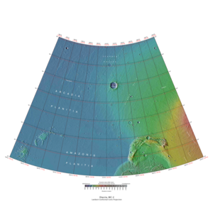
Diacria quadrangle
The Diacria quadrangle is one of a series of 30 quadrangle maps of Mars used by the United States Geological Survey (USGS) Astrogeology Research Program . The quadrangle is located in the northwestern portion of Mars’ western hemisphere and covers 180° to 240° east longitude (120° to 180° west longitude) and 30° to 65° north latitude. The quadrangle uses a Lambert conformal conic projection at a nominal scale of 1:5,000,000 (1:5M). The Diacria quadrangle is also referred to as MC-2 (Mars Chart-2). [1] The Diacria quadrangle covers parts of Arcadia Planitia and Amazonis Planitia .
Page Revisions
| Year | Metadata | Sections | Top Words | First Paragraph |
| 2018 |
183061 characters 25 sections 75 paragraphs 55 images 317 internal links 40 external links |
3. What does the surface look like 10. Depressions in Milankovic Crater |
hiwish 0.277 diacria 0.276 hirise 0.240 streaks 0.225 ice 0.223 dust 0.197 program 0.156 acheron 0.156 lycus 0.151 sulci 0.147 alba 0.138 arcadia 0.127 mons 0.118 planitia 0.114 dark 0.107 |
The Diacria quadrangle is one of a series of 30 quadrangle maps of Mars used by the United States Geological Survey (USGS) Astrogeology Research Program . The quadrangle is located in the northwestern portion of Mars’ western hemisphere and covers 180° to 240° east longitude (120° to 180° west longitude) and 30° to 65° north latitude. The quadrangle uses a Lambert conformal conic projection at a nominal scale of 1:5,000,000 (1:5M). The Diacria quadrangle is also referred to as MC-2 (Mars Chart-2). [1] The Diacria quadrangle covers parts of Arcadia Planitia and Amazonis Planitia . |
| 2017 |
166310 characters 23 sections 63 paragraphs 43 images 316 internal links 33 external links |
3. What does the surface look like |
diacria 0.302 streaks 0.246 dust 0.216 ice 0.202 hiwish 0.186 hirise 0.180 acheron 0.171 lycus 0.165 sulci 0.161 alba 0.151 arcadia 0.139 mons 0.129 planitia 0.125 dark 0.117 fossae 0.109 |
The Diacria quadrangle is one of a series of 30 quadrangle maps of Mars used by the United States Geological Survey (USGS) Astrogeology Research Program . The quadrangle is located in the northwestern portion of Mars’ western hemisphere and covers 180° to 240° east longitude (120° to 180° west longitude) and 30° to 65° north latitude. The quadrangle uses a Lambert conformal conic projection at a nominal scale of 1:5,000,000 (1:5M). The Diacria quadrangle is also referred to as MC-2 (Mars Chart-2). [1] The Diacria quadrangle covers parts of Arcadia Planitia and Amazonis Planitia . |
| 2016 |
145508 characters 20 sections 48 paragraphs 36 images 310 internal links 28 external links |
3. What does the surface look like |
diacria 0.337 streaks 0.275 dust 0.213 acheron 0.190 lycus 0.184 sulci 0.180 alba 0.169 hirise 0.150 mons 0.144 hiwish 0.142 arcadia 0.136 dark 0.131 planitia 0.129 fossae 0.122 ice 0.119 |
The Diacria quadrangle is one of a series of 30 quadrangle maps of Mars used by the United States Geological Survey (USGS) Astrogeology Research Program . The quadrangle is located in the northwestern portion of Mars’ western hemisphere and covers 180° to 240° east longitude (120° to 180° west longitude) and 30° to 65° north latitude. The quadrangle uses a Lambert conformal conic projection at a nominal scale of 1:5,000,000 (1:5M). The Diacria quadrangle is also referred to as MC-2 (Mars Chart-2). [1] The Diacria quadrangle covers parts of Arcadia Planitia and Amazonis Planitia . |
| 2015 |
126436 characters 17 sections 43 paragraphs 31 images 276 internal links 25 external links |
3. What does the surface look like |
diacria 0.334 streaks 0.264 dust 0.226 alba 0.179 acheron 0.168 mons 0.153 arcadia 0.144 sulci 0.143 lycus 0.140 hirise 0.137 planitia 0.137 dark 0.124 cyane 0.120 quadrangle 0.119 fossae 0.117 |
The Diacria quadrangle is one of a series of 30 quadrangle maps of Mars used by the United States Geological Survey (USGS) Astrogeology Research Program . The quadrangle is located in the northwestern portion of Mars’ western hemisphere and covers 180° to 240° east longitude (120° to 180° west longitude) and 30° to 65° north latitude. The quadrangle uses a Lambert conformal conic projection at a nominal scale of 1:5,000,000 (1:5M). The Diacria quadrangle is also referred to as MC-2 (Mars Chart-2). [1] The Diacria quadrangle covers parts of Arcadia Planitia and Amazonis Planitia . |
| 2014 |
121744 characters 15 sections 40 paragraphs 29 images 272 internal links 25 external links |
3. What does the surface look like 7. Depressions in Milankovic Crater |
diacria 0.303 streaks 0.280 dust 0.239 alba 0.190 acheron 0.178 mons 0.162 dark 0.131 arcadia 0.131 hirise 0.129 cyane 0.127 sulci 0.126 fossae 0.123 planitia 0.120 lycus 0.118 quadrangle 0.117 |
The Diacria quadrangle is one of a series of 30 quadrangle maps of Mars used by the United States Geological Survey (USGS) Astrogeology Research Program . The quadrangle is located in the northwestern portion of Mars’ western hemisphere and covers 180° to 240° east longitude (120° to 180° west longitude) and 30° to 65° north latitude. The quadrangle uses a Lambert conformal conic projection at a nominal scale of 1:5,000,000 (1:5M). The Diacria quadrangle is also referred to as MC-2 (Mars Chart-2). [1] |
| 2013 |
120780 characters 15 sections 40 paragraphs 28 images 272 internal links 24 external links |
3. What does the surface look like 7. Depressions in Milankovic Crater |
diacria 0.303 streaks 0.280 dust 0.239 alba 0.190 acheron 0.178 mons 0.162 dark 0.131 arcadia 0.131 hirise 0.129 cyane 0.127 sulci 0.126 fossae 0.123 planitia 0.120 lycus 0.118 quadrangle 0.117 |
The Diacria quadrangle is one of a series of 30 quadrangle maps of Mars used by the United States Geological Survey (USGS) Astrogeology Research Program . The quadrangle is located in the northwestern portion of Mars’ western hemisphere and covers 180° to 240° east longitude (120° to 180° west longitude) and 30° to 65° north latitude. The quadrangle uses a Lambert conformal conic projection at a nominal scale of 1:5,000,000 (1:5M). The Diacria quadrangle is also referred to as MC-2 (Mars Chart-2). [1] |
| 2012 |
118976 characters 15 sections 41 paragraphs 27 images 271 internal links 24 external links |
3. What does the surface look like 7. Depressions in Milankovic Crater |
diacria 0.303 streaks 0.280 dust 0.239 alba 0.190 acheron 0.178 mons 0.162 dark 0.131 arcadia 0.131 hirise 0.129 cyane 0.127 sulci 0.126 fossae 0.123 planitia 0.120 lycus 0.118 quadrangle 0.117 |
The Diacria quadrangle is one of a series of 30 quadrangle maps of Mars used by the United States Geological Survey (USGS) Astrogeology Research Program . The quadrangle is located in the northwestern portion of Mars’ western hemisphere and covers 180° to 240° east longitude (120° to 180° west longitude) and 30° to 65° north latitude. The quadrangle uses a Lambert conformal conic projection at a nominal scale of 1:5,000,000 (1:5M). The Diacria quadrangle is also referred to as MC-2 (Mars Chart-2). [1] |
| 2011 |
62714 characters 13 sections 34 paragraphs 15 images 129 internal links 16 external links |
diacria 0.313 streaks 0.289 dust 0.247 alba 0.196 acheron 0.184 mons 0.167 arcadia 0.135 cyane 0.131 fossae 0.127 dark 0.127 planitia 0.124 quadrangle 0.120 flank 0.115 aureole 0.113 olympus 0.111 |
|
|
| 2010 |
57118 characters 13 sections 34 paragraphs 14 images 125 internal links 14 external links |
diacria 0.334 dust 0.238 alba 0.209 acheron 0.196 mons 0.178 streaks 0.178 arcadia 0.144 cyane 0.140 fossae 0.136 planitia 0.133 quadrangle 0.123 flank 0.123 aureole 0.120 olympus 0.118 sulci 0.111 |
The Diacria quadrangle is one of a series of 30 quadrangle maps of Mars used by the United States Geological Survey (USGS) Astrogeology Research Program . The quadrangle is located in the northwestern portion of Mars’ western hemisphere and covers 180° to 240° east longitude (120° to 180° west longitude) and 30° to 65° north latitude. The quadrangle uses a Lambert conformal conic projection at a nominal scale of 1:5,000,000 (1:5M). The Diacria quadrangle is also referred to as MC-2 (Mars Chart-2). [1] |
|
| 2009 |
50399 characters 12 sections 27 paragraphs 11 images 113 internal links 13 external links |
diacria 0.291 dust 0.231 alba 0.219 acheron 0.205 mons 0.186 streaks 0.186 arcadia 0.151 cyane 0.146 fossae 0.142 planitia 0.139 erebus 0.136 quadrangle 0.129 flank 0.128 aureole 0.126 olympus 0.123 |
The Diacria quadrangle is one of a series of 30 quadrangle maps of Mars used by the United States Geological Survey (USGS) Astrogeology Research Program . The quadrangle is located in the northwestern portion of Mars’ western hemisphere and covers 180° to 240° east longitude (120° to 180° west longitude) and 30° to 65° north latitude. The quadrangle uses a Lambert conformal conic projection at a nominal scale of 1:5,000,000 (1:5M). The Diacria quadrangle is also referred to as MC-2 (Mars Chart-2). [1] |